A new group for 2024, during January and February we ran an induction program to get newcomers up to speed of our regular walks.This has now been completed and the succesfull walkers have moved on to the other regular walking groups in MKU3A.
The programme of walks, the start points and the route maps are listed below as a resource for individuals to complete a self-guided programme of walks to get themselves up to speed to join the existing walking groups.
New walkers should familiarise themselves with the What3word App as it is the most efficient way to describe locations like car parks which do not always have a useful postcode and includes navigation instructions from your location including current traffic and roadworks information.
If sufficient people are interested in being led on this programme then they can ask to be added to the waiting list, and when the waiting list reaches in excess of 30 I will see if I can run another programme, or maybe someone else would like to volunteer to run the programme. Interested members should email the group admin to be added to the group waiting list - Richard Barrett redwayswalkers@mku3a.org
Walk Programme
|
|
Walk time minutes
|
Distance miles
|
Speed mph
|
Terrain
|
Early finish after miles
|
Walk Map
|
|
Walk 1
|
60
|
2.6
|
2.6
|
Level Redways
|
1.7
|
Walk 1 - 2.6 miles.pdf
|
|
Walk 2
|
60
|
2.6
|
2.6
|
Level Redways
|
1.9
|
Walk 2 - 2.6 miles.pdf
|
|
Walk 3
|
60
|
2.6
|
2.6
|
Level Redways
|
2.1
|
Walk 3 - 2.6 miles.pdf
|
|
Walk 4
|
60
|
2.7
|
2.7
|
Level Redways
|
2.3
|
Walk 4 - 2.7 miles.pdf
|
|
Walk 5
|
60
|
2.7
|
2.7
|
Level Redways
|
2.5
|
Walk 5 - 2.7 miles.pdf
|
|
Walk 6
|
60
|
2.8
|
2.75
|
Level Redways
|
-
|
Walk 6 - 2.8 miles.pdf
|
|
Walk 7
|
60
|
2.8
|
2.75
|
With hill section
|
-
|
Walk 7 - 2.9 miles.pdf
|
|
Walk 8
|
60
|
2.8
|
2.75
|
With hill section
|
-
|
Walk 8 - 2.7 miles.pdf
|
|
Walk 9
|
65
|
3.0
|
2.75
|
Mixed Redways
|
-
|
Walk 9 - 3 miles.pdf
|
|
Walk 10
|
70
|
3.2
|
2.75
|
Mixed Redways
|
-
|
Walk 10 - 3.2 miles.pdf
|
|
Walk 11
|
75
|
3.4
|
2.75
|
Mixed Redways
|
-
|
Walk 11 - 3.4 miles.pdf
|
|
Walk 12
|
80
|
3.7
|
2.75
|
Mixed Redways
|
-
|
Walk 12 - 3.7 miles.pdf
|
|
Walk 13
|
85
|
3.9
|
2.75
|
Mixed Redways
|
-
|
Walk 13 - 3.9 miles.pdf
|
|
Walk 14
|
90
|
4.1
|
2.75
|
Mixed Redways
|
-
|
Walk 14 - 4.2 miles.pdf
|
|
Walk 15
|
95
|
4.4
|
2.75
|
Mixed Redways
|
-
|
Walk 15a - 4.8 miles.pdf
|
|
Walk 16
|
100
|
4.6
|
2.75
|
Mixed Redways
|
-
|
Walk 16 4.8 miles.pdf
|
The programme builds up speed on level paths until week 4 when there will be some small hills (this is MK - no mountains). Then each walk will be 5 minutes longer and maintaining a level speed they will include undulating paths mainly Redways.
The walks
The first few walks all contain a shortcut back to the start if the full distance is too much. If you are not ready to move up to the next level you can repeat the walks in the opposite direction.
All the car parks used are free to use.
Walks 1 - 8 all start from the Old Cricket Ground car park in Woolstone, the postcode in MK15 0BP and the What3word link is https://w3w.co/presides.dummy.mailings?zoomlevel=16
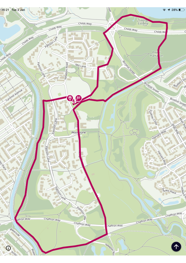
Walk 1 - 2.6 miles or 1.7 miles using the shortcut
© OpenStreetMap contributors
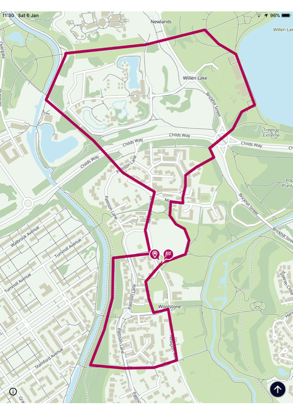
Walk 2 - 2.6 miles or 1.9 miles using the shortcut
© OpenStreetMap contributors
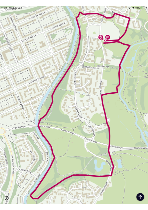
Walk 3 - 2.6 miles or 2.1 miles using the shortcut
© OpenStreetMap contributors
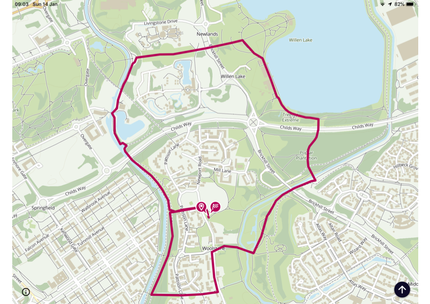
Walk 4 - 2.7 miles or 2.3 miles using the shortcut
© OpenStreetMap contributors
Walk 5 - 2.7 miles or 2.5 miles using the shortcut
© OpenStreetMap contributors
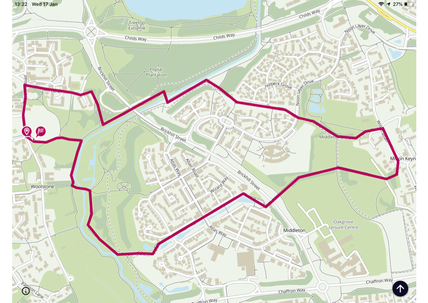
Walk 6 - 2.8 miles
© OpenStreetMap contributors
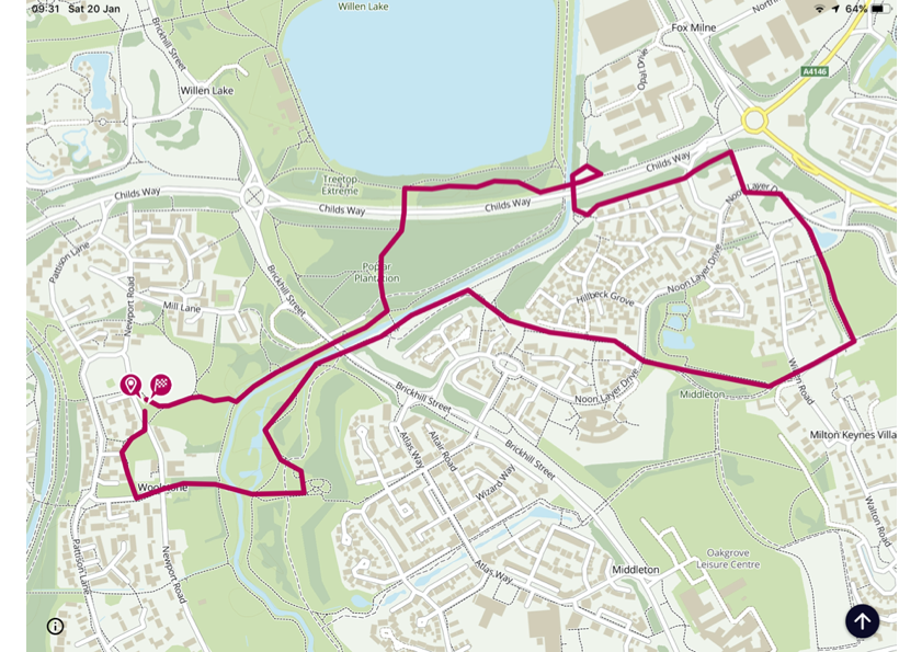
Walk 7 - 2.9 miles
© OpenStreetMap contributors
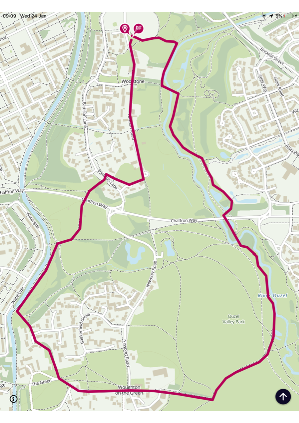
Walk 8 - 2.7 miles
© OpenStreetMap contributors
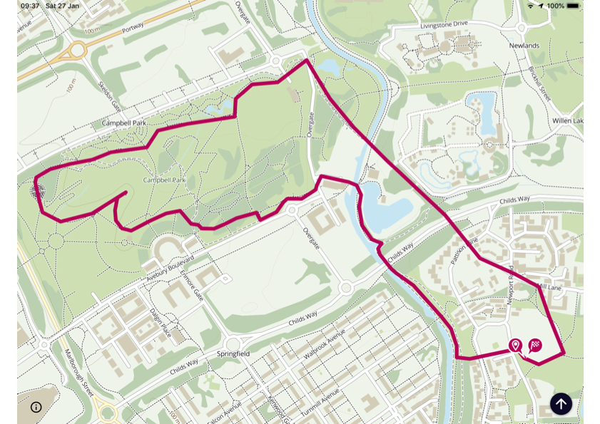
Walks 9 - 11 all start from the Memorial Hall in Great Lindford, approximate postcode is MK15 5AS and the What3word link is https://w3w.co/groups.overlaid.swimmer?zoomlevel=16
Walk 9 - 3.0 miles
© OpenStreetMap contributors
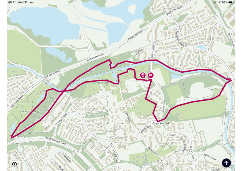
Walk 10 - 3.2 miles
© OpenStreetMap contributors
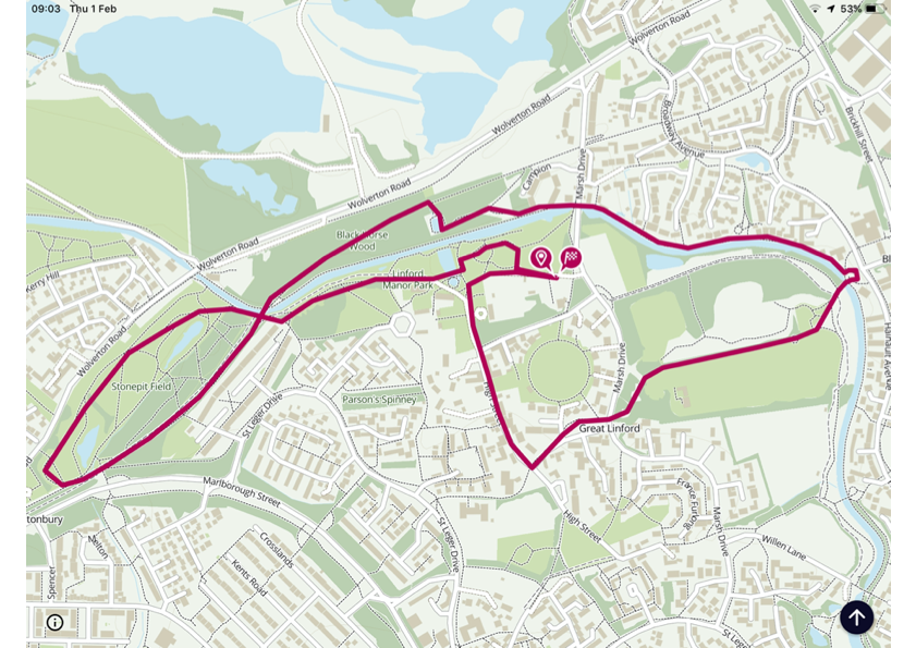
Walk 11 - 3.6 miles including ROCLA Art Trail
© OpenStreetMap contributors
Walks 12 - 13 start from the Park Trust's, Stanton Low Country Park car park, an approximate postcode is MK14 6FF and the What3word link is https://w3w.co/tightest.eats.both?zoomlevel=16
Walk 12 - 3.7 miles
© OpenStreetMap contributors
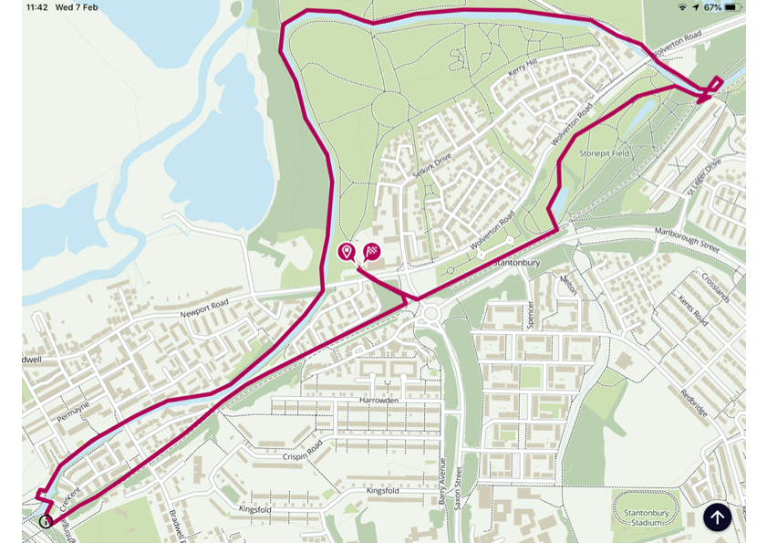
Walk 13 - 3.7 miles
© OpenStreetMap contributors
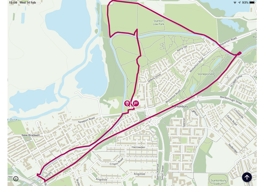
Walks 14 and 15 start from the Parks Trust's North Caldecott car park on Simpson Road, an approximate postcode is MK6 3AD and the What3word link is https://w3w.co/palms.wonderfully.spend?zoomlevel=16
Walk 14 - 4.2 miles
© OpenStreetMap contributors
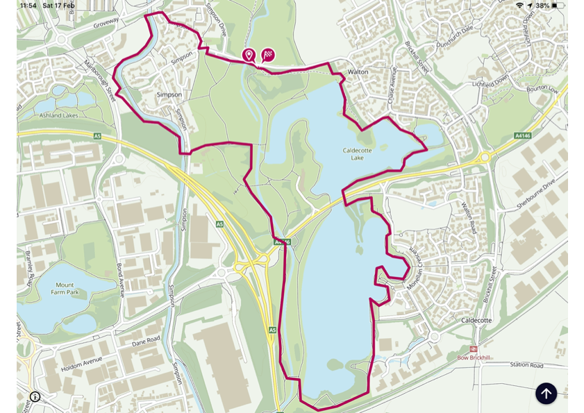
Walk 15a (this is the planned walk which was flooded and we actually walked over Kent's Hill - this walk is better)
© OpenStreetMap contributors
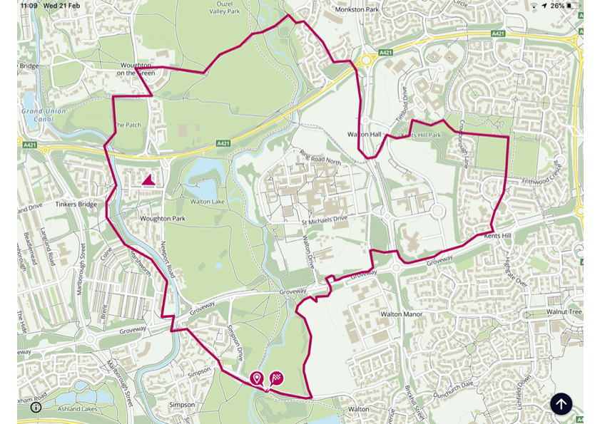
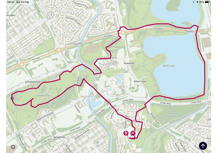
Walk16 - 4.8 miles
This walk starts where we began, from the Old Cricket Ground car park in Woolstone, the postcode in MK15 0BP and the What2word link is https://w3w.co/presides.dummy.mailings?zoomlevel=16
© OpenStreetMap contributors
And that concludes our walk programme.
Let me know if you enjoyed this walking programme.
Richard Barrett
 Return to Top ▲